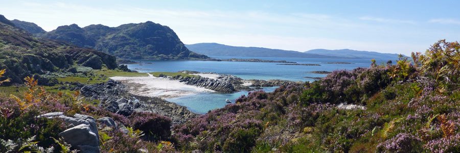
, Port Appin")
A lovely short coastal walk along a promontory at Port Appin. Good views are afforded of Loch Linnhe, the Lynn of Lorne, the Isle of Lismore and the distant hills of Morvern and Mull.
Walks around Fort William, Glencoe and Glen Nevis
Walks around Fort William, Glencoe and Spean Bridge from our sister website Wild About Lochaber. See individual walking pages for OS maps.
For accommodation in the Fort William area see our Fort William Accommodation Map.
terrain: track, path & road
grade: easy
length: 2.2 km (1.4 miles)
grid ref: NM903453
type: circular
terrain: path and road
grade: easy
length: 3 km (1.9 miles)
grid ref: NM924465
type: circular

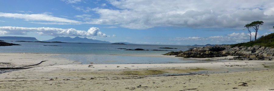
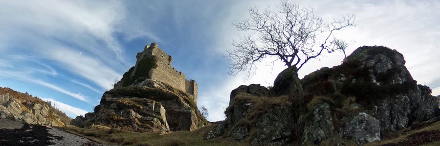
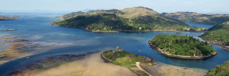
A lovely short walk over the historic 19th century jubilee bridge crossing salt marsh and affording fine views of Castle Stalker, Appin.
![]()
terrain: woodand path - steep in places
grade: easy
length: 1km (0.6 miles)
grid ref: NN001454
type: circular

A lovely walk through Glasdrum National Nature Reserve, a woodland reserve renowned for it’s exceptional bryophyte and lichen flora, as well as one of the top sites for chequered skipper and pearl border fritillary butterflies. The walk affords some stunning views of Glen Creran and the fjordic...
![]()
terrain: good path and forest track
grade: easy
length: 5km (3.1 miles)
grid ref: NN030634
type: circular

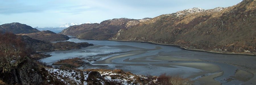
A circular walk up a gorge passing eight mighty falls and onwards along a section of historic Wade's road returning with magnificant views of Loch Linnhe
![]()
terrain: grassy path and track
grade: easy
length: 2.2 km (1.4 miles)
grid ref: NN036488
type: circular

A lovely short walk through plantation and mixed deciduous woodland in Glen Creran with some fine views, historical connections and good wildlife spotting opportunities.
![]()
terrain: path and road
grade: easy
length: 2.9km (1.8 miles)
grid ref: NN084584
type: circular

A lovely walk, mainly through plantation, on a well defined path, with some stunning views of the surrounding hills and of Loch Leven and Loch Linnhe. The route starts at the former Ballachulish Slate Quarry and returns through the lovely village of Ballachulish.
![]()
terrain: canalside path
grade: easy
length: 4.7km (2.9 miles)
grid ref: NN097767
type: circular

Neptune's Staircase and Corpach. A very pleasant canal side walk with stunning views of the Nevis Range and the hills of Ardgour. A lovely walk for the canal and wildlife enthusiast alike.
![]()
terrain: path and road
grade: easy
length: 4.5km (2.75 miles)
grid ref: NN105743
type: circular

A pleasant walk between the Old Fort in Fort William and Old Inverlochy Castle along the banks of the River Lochy. The return route is through the village of Inverlochy, with its tribute to Aluminium Industry, the main employer of the region.
![]()
terrain: track and path
grade: moderate
length: 8.9 km (5.6 miles)
grid ref: NN111742
type: circular

This is a fabulous walk through deciduous woodland, forestry plantation and heathland to Cow Hill, affording some stunning views of the Ben Nevis Range , Loch Linnhe and Loch Eil and the township of Fort William and its environs.
![]()
terrain: path
grade: easy
length: 1.3 - 5 km (1 - 3 miles)
grid ref: NN105594
type: circular

An interesting walk around a lochan and through planted coniferous and native deciduous woodland. There are lovely views of Bidean Nam Bian and The Pap of Glencoe, which dominate the landscape.
![]()
terrain: grassy path
grade: easy
length: 1.6 km (1 mile)
grid ref: NN120911
type: circular

Alt Mhuic Butterfly Reserve is on the north shores of Loch Arkaig in Lochaber. The reserve is managed jointly for the conservation of butterflies by the Forestry Commission and the Butterfly Conservation.
![]()
terrain: track and path
grade: moderate
length: 10.5km (6.5 miles)
grid ref: NM122736
type: there and back

The walk to the vitrified iron age fort at Dun Deardail is a is a lovely scenic walk along forest tracks, with fine views of Ben Nevis, the Nevis Range and Glen Nevis
![]()
terrain: woodland path
grade: moderate
length: 3km (1.9 miles)
grid ref: NN128564
type: circular

A lovely short walk through coniferous plantation to Signal Rock; reputed to be a gathering place for the MacDonalds of Glencoe at times of trouble and the place where, according to legend, the signal was given by the Campbells for the Glencoe Massacre.
![]()
terrain: towpath and road
grade: easy
length: 6.6 km (4.1 miles)
grid ref: NN144811
type: circular

The walk includes a lovely section along the Caledonian Canal passing between two aqueducts (Shengain Aqueduct and Glen Loy Aqueduct), and incorporates part of the Great Glen Way.
![]()
terrain: uneven path
grade: moderate
length: 5.2km (3.2 miles)
grid ref: NN168691
type: there and back

A lovely walk through the steep-sided Nevis Gorge to an impressive waterfall, An Steall, cascading from a hanging valley (Coire A’ Mhail). This is a very impressive short walk with much geological and botanical interest, as well as stunning mountain views of the slopes of Ben Nevis, and some of...
![]()
terrain: canal path and road
grade: easy
length: 6.2km (3.9 miles)
grid ref: NN175842
type: circular

A pleasant short circular walk along the towpath of the Caledonian Canal to Moy Bridge, returning along a minor road (B8004).
![]()
terrain: good path and road
grade: easy
length: 4.7 km (3 miles)
grid ref: NN208824
type: circular

A lovely historic walk from The Commando Memorial along the banks of the River Spean passing by the historic High Bridge with fine views of the Nevis Range.
![]()
terrain: track and path
grade: easy
length: 2 km & 5.4 km (1.2 & 3.4 miles)
grid ref: NH283014
type: circular

Two lovely short walks in the Glen Garry Native Pinewoods (Ciste Dubh Trail and Alt na Cailliche). Both routes pass through deciduous and pine woodland in The Glen Garry Forest Area, following the River Garry for part of the way, and affording some lovely views.
![]()
terrain: good path
grade: moderate
length: 12km (7.5 miles)
grid ref: NN483873
type: there and back

A stunning walk with fabulous hill views to lochan a Choire in Coire Ardair, following the watercourse, Allt Coire Ardair, in the Creag Meagaidh National Nature Reserve
![]()
terrain: good path
grade: easy
length: 1 & 2km (.6 & 1.2 miles)
grid ref: NN483873
type: circular

Three lovely short walks from the car park in Creag Meagaidh National Nature Reserve providing an opportunity to experience various habitats, including meadow, ancient alder woodland and heath land. The walks offer some stunning of views of Creag Meagaidh massif and Loch Laggan.
![]()