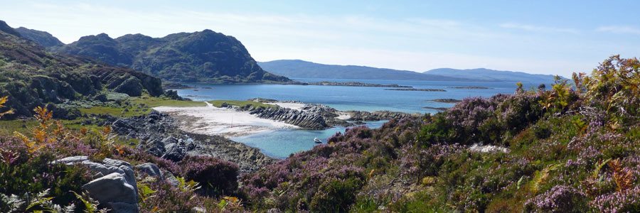
A walk to a beautiful beach on the Ardnamurchan peninsula with fabulous views of Skye, the Small Isles and Ardnamurchan Point. The beach is fabulous with white sands and clear turquoise seas, with an abundance of shells on the strand line. Look out for raptors, including golden eagle, in the...
Ardnamurchan Walks
Discover the wild side of Ardnamurchan with our wildlife focused walks on The Ardnamurchan Peninsula, Moidart, Sunart and Strontian on The West Coast of Scotland. Ardnamurchan offers a selection of walks for all abilities with great opportunities for wildlife watching and stunning scenery. See individual walking pages for OS maps and route descriptions in Ardnamurchan, Moidart and Strontian.
terrain: grassy path and beach
grade: easy
length: 2.6km (1.6 miles) or less
grid ref: NM429671
type: there and back
terrain: gentle hills and beach
grade: moderate
length: 6.6km (4 miles)
grid ref: NM439681
type: lollipop

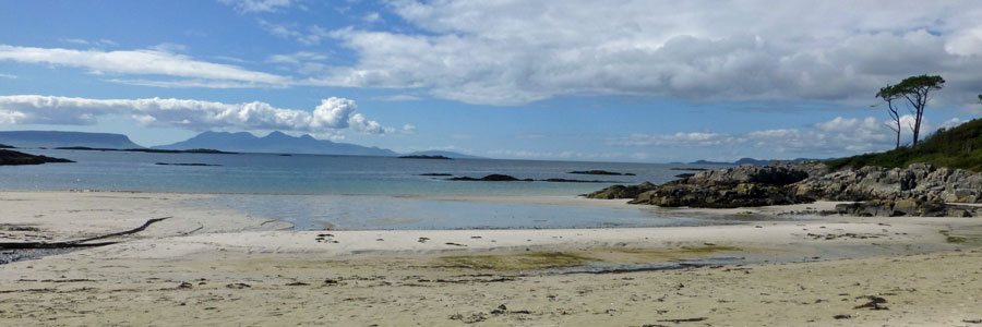
A fantastic walk to the beautiful white sandy beaches of Sanna bay on the Ardnamurchan peninsula, with the option of extending the walk to the hills beyond the dunes. The walk affords amazing views of Ardnamurchan Point and the Small Isles, as well as providing the opportunity to explore...
![]()
terrain: woodland and moorland path - boggy
grade: moderate
length: 2.4km (1.5 miles)
grid ref: NM450666
type: circular

A little gem of a walk through hazel woodland to open heathland offering a real taste of wild Ardnamurchan. A great short and highly rewarding walk, providing an opportunity to explore some fine wood and open habitats and, if lucky, encountered some iconic species. There are spectacular views...
![]()
terrain: track and boggy path
grade: challenging
length: 9km (5.6 miles)
grid ref: NM470678
type: there and back

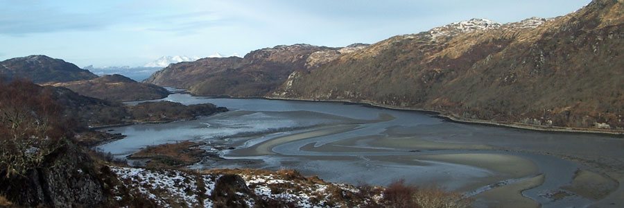
A stunning walk affording panoramic views of a volcanic ring dyke and caldera, the remains of an ancient volcano on the Ardnamurchan peninsula. The walk also offers an opportunity to explore the deserted village of Glendrian (option 1) and as well as a more challenging route (option 2) to the...
![]()
terrain: track and field
grade: easy
length: 1.2km (0.75 miles)
grid ref: NM479636
type: there and back

A short walk to admire the remains of the chambered cairn, Greadal Fhinn, on the summit of a knoll at Ormsaigmore on the Ardnamurchan peninsula. The Neolithic cairn contains two chambers, a larger passage grave on south-eastern edge of the mound and a smaller central cist. Most of the cairn...
![]()
terrain: grassy path and beach
grade: easy
length: 2.6km (1.6 miles) or less
grid ref: NM429671
type: there and back

A walk to a beautiful beach on the Ardnamurchan peninsula with fabulous views of Skye, the Small Isles and Ardnamurchan Point. The beach is fabulous with white sands and clear turquoise seas, with an abundance of shells on the strand line. Look out for raptors, including golden eagle, in the...
![]()
terrain: boggy path
grade: moderate
length: 7km (4.4 miles)
grid ref: NM502707
type: there and back

A lovely walk along a glen from Fascadale Bay to the shingle inlet of Port Eigin-aig on the Ardnamurchan peninsula, with good chances of seeing raptors and red deer.
There are some lovely views of the surrounding low hills of the Glen, dominated by Meall an Fhir-eoin and the surrounding...
![]()
terrain: grassy path
grade: easy
length: 1.4km (0.9 miles)
grid ref: NM500636
type: there and back

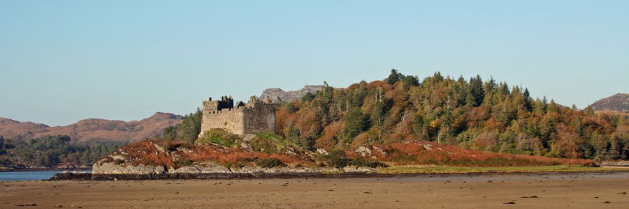
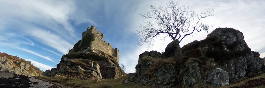
Please note as of 2013 access to Mingarry Castle is not possible due to restoration work.
A short walk to Mingary Castle and to a lovely rocky shoreline and shingle beach. The route heads through rough grassland/pasture, and affords good views of Ben Hiant and Beinn na-h...
![]()
terrain: grassy path and track
grade: easy
length: 1.6km (1 mile)
grid ref: NM529701
type: there and back

A short walk to Kilmory Beach on the Ardnamurchan peninsula, a lovely sheltered sandy beach on the north coast of the Ardnamurchan peninsula. The beach is punctuated by numerous rocky outcrops of heavily jointed igneous rocks, and fringed with green and purple hued boulders and shingle. The...
![]()
terrain: grassy path
grade: moderate
length: 4.4km (2.75 miles
grid ref: NM551641
type: there and back

The austere rugged profile of Ben Hiant (528m) dominates the northern shore of Loch Sunart of the Ardnamurchan peninsula with its bare rock exposures and jutting outcrops.
Ben Hiant epitomises the complex geology of the Ardnamurchan region being a conglomeration of quartz-dolerite,...
![]()
terrain: track and path
grade: moderate
length: 15.8 km (9.9 miles)
grid ref: NM555704
type: there and back

This is a stunning walk across a wild rugged terrain to a beautiful beach. The walk passes through heathland with some stunning coastal and hill views, with particularly fine views to the Small Isles, Mull and Skye. Gortenfern beach is lovely sandy beach and a great...
![]()
terrain: path, track and shingle beach
grade: moderate
length: 5.4km (3.4 miles)
grid ref: NM563616
type: there and back

An interesting walk along the rocky shore line from the inlet at Camus nan Geall on the Ardnamurchan peninsula. The fertile ground on Camus nan Geall has a long history of settlement as evidenced by an ancient chambered cairn and standing stone. The site has also served as a burial ground...
![]()
terrain: path with steep ascent/descent
grade: moderate
length: 2.6km (1.6 miles)
grid ref: NM601608
type: circular

Glenborrodale on the Ardnamurchan peninsula is the RSPB’s most westerly reserve and managed for its oak woodlands. This is a pleasant walk through deciduous woodland onto heath/moorland on the north shore of Loch Sunart, with excellent views over Loch Sunart.
A good spot for raptors on...
![]()
terrain: rough track, boggy
grade: moderate
length: 6.5km (4 miles)
grid ref: NM654773
type: there and back

A pleasant walk along a rough/coastal path to the ancient crofting village of Smirisary in Moidart and onto the silvery sands. Good views over the Bay of Arisaig and to the Small Isles. The species-rich coastal grassland, the sandy shell beach and clear blue seas make it an ideal spot for...
![]()
terrain: mainly forest track
grade: moderate
length: 9.8km (6.2miles)
grid ref: NM650677
type: there and back

An enjoyable walk to the beautiful Singing Sands at Gortenfern in the Ardnamurchan, skirting around the southern edge of Kentra Bay and then through coniferous plantation. Kentra Bay contains a large expanse of mudflat at low tide and small fragments of salt marsh, sand dune and machair. The...
![]()
terrain: track
grade: easy
length: 4.6km (2.9 miles)
grid ref: NM664720
type: there and back

An easy and enjoyable walk from Castle Tioram at Dorlin along the banks of the River Shiel with good opportunities for spotting wildlife.
The walk gives an opportunity to enjoy heathland, woodland and coastal habitat. At low tide the large sandy beach by Castle Tioram is a good place for...
![]()
terrain: rough track - vertiginous in places
grade: moderate
length: 6.1 km (3.8 miles)
grid ref: NM664714
type: circular

A very pleasant and interesting walk through woodland, heathland, moorland and along coastal tracks with stunning views over Loch Moidart with its many pine clad islands and Castle Tioram.
The route follows small water courses lined with mainly alder, birch, ash, willow and ash; the...
![]()
terrain: woodland path
grade: moderate
length: 1 km (0.8 miles)
grid ref: NM665670
type: there and back

A stunning walk to the vitrified iron-aged fort at Shielfoot Torr. A secret journey through ancient oak woodlands to the knife edge ridge with stunning views over The River Shiel and beyond.
The route to the fortifactions on Shielfoot Toor passes through some lovely deciduous ancient...
![]()
terrain: open hillside
grade: moderate
length: 2.6km (1.6 miles)
grid ref: NM675713
type: there and back

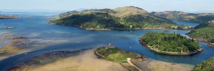
This amazing viewpoint overlooking Castle Tioram and Loch Moidart is just a short diversion from the Blain Burn or Castle Tioram Circular walks and well worth the effort for some amazing views and photographic opportunites. There are several routes up to the viewpoint, though we find this one...
![]()
terrain: track and road
grade: moderate
length: 6.9km (4.3 miles) with optional shortcuts
grid ref: NM674680
type: circular

A circular walk on track and road across Kentra Moss with good opportunities for botanising and bird watching. Kentra Moss, together with nearby Claish Moss, is one of the few examples of eccentric mires in Britain being a fine example of oceanic blanket bog.
The walk provides good...
![]()
terrain: track and path
grade: moderate
length: 6.4 km (4 miles)
grid ref: NM677694
type: circular

A lovely walk through woodland and then out onto open heath , skirting around the edge of Blain lochan with good views of the surrounding hills of Beinn Gheur and Beinn Bhreac and stunning views over Loch Moidart to the Small Isles. There is an opportunity to take a...
![]()
terrain: Forest track
grade: easy
length: 12 km (7.5 miles)
grid ref: NM690659
type: there and back

A lovely walk through mainly coniferous woodland on a forest track with some fine glimpses of Ben Repisole on route, and of Loch Shiel towards the end of the track. There is an optional detour to the edges of Claish Moss approximately 2 miles from the start of the walk.
The forest track...
![]()
terrain: path, vertginous in places
grade: moderate
length: 3.6km (2.2 miles)
grid ref: NM694728
type: circular

A pleasant, scenic walk and interesting walk along the old track on the north side of Loch Moidart that formerly connected Glenuig and Kinlochmoidart. There are excellent views of Loch Moidart on route.
The area has a long history and turbulent history of occupation, including an Iron...
![]()
terrain: woodland track
grade: easy
length: 1.7 km (1.1 miles)
grid ref: NM691645
type: circular

An interesting and enjoyable way-marked circular woodland walk through a lovely section of Atlantic oak woodland on the northern shore of Loch Sunart, with good coastal views of Salen Bay and Loch Sunart.
The path is way marked and well defined, with a few small ascents and descents on...
![]()
terrain: track and path
grade: easy
length: 1.5-3km (1-2 miles)
grid ref: NM693644
type: lollipop

The Salen Alphabet Trail provides an interesting introduction to the importance of nature and plants to the Gaelic culture. The information boards in the car park introduce the Gaelic alphabet which has eighteen letters, each of which is associated with a species of tree. The walk also...
![]()
terrain: woodland path
grade: easy
length: 0.7km (0.5 miles)
grid ref: NM702644
type: circular

The Bay of Flies, near Salen in the Ardnamurchan is a natural harbour formerly used to export goods, such as charcoal, oak bark and brushwood. The Viking's were also reputed to have stored their boats over winter in the harbour. The short, circular walk descends along a well-defined path...
![]()
terrain: path, track and road
grade: moderate
length: 3km (1.9 miles) and 2.6km (1.6miles)
grid ref: NM710727
type: circular

The Prince's Walk is an interesting circular walk through the grounds of Kinlochmoidart estate and woodlands (marked red on the map). The walk is named after the association of the original house with the 1745 uprising in support of Princes Charles.
The route passes...
![]()
terrain: mixed
grade: moderate
length: 12.6km (7.9 miles)
grid ref: NM716714
type: there and back

A lovely, but fairly strenuous, and long coastal walk along the shores of Loch Moidart, with the possibility of seeing otters and a range of coastal birds. The walk is a ‘there and back’, although parts of the Silver Walk are incorporated into other routes, namely Blain Burn and Castle Tioram...
![]()
terrain: forest and moorland track
grade: moderate
length: 3.3km (2 miles)
grid ref: NM716714
type: lollipop

A magical woodland walk through coniferous plantations to the hills beside Loch Moidart. This is a fairly strenuous, circular walk through mainly coniferous woodland into the hills, with some steep ascents on well defined paths. Excellent views afforded over Loch Moidart to the Small Isles...
![]()
terrain: mountain track
grade: challenging
length: 16km

Ben Resipole, a Corbett, is the highest peak on the Ardnamurchan, and affords spectacular views of Loch Shiel, Loch Sunart, the Small Isles and Skye on a clear day. The route is strenuous and the path is muddy and indistinct in places. However, the walk is enriched by the changing vegetation...
![]()
terrain: track
grade: moderate
length: 4.4km & 8.3km (1.4 & 5.1 miles) there and back
grid ref: NM734691
type: there and back

A starting point for two very pleasant walks-Dalilea to the Green Isle walk, and the Dalilea to Kinlochmoidart walk.
The Green Isle Walk
The Green Isle Walk is a short pleasant walk along a track along the shores of Loch Shiel through rough grassland and pockets...
![]()
terrain: track
grade: moderate
length: 5.2km (3.2 miles)
grid ref: NM740722
type: there and back

An enjoyable walk following a gravelled track with good views of the hill lochan, Loch nan Lochan, and ascending to the reservoir at Glen Forslan. Fine hill scenery and the picturesque falls of Glenforslan make this a very pleasant walk. In addition, devil's bit scabious (Succisa patensis...
![]()
terrain: track - steep in places
grade: easy
length: 1.5km (1 mile)
grid ref: NM746619
type: there and back

An occasionally steep, but well surfaced, gravel path meandering through native woodland from Ardery to the Garbh Eilean Wildlife Hide. The walk takes you through oak and birch woodland with an understory of mainly heather and bilberry (Calluna vulgaris, Vaccinium spp and ...
![]()
terrain: Forest track and path
grade: easy
length: 4.75km (3 miles)
grid ref: NM792688
type: lollipop

A pleasant walk in the Glenhurich Forest mainly along a forest track from Polloch, near Strontian, to the shores of Loch Shiel. The route passes through coniferous plantation, heath, and woodland. There are two viewpoints on route providing fine views across Loch Shiel whose restless waters...
![]()
terrain: track and path
grade: moderate
length: 7.6km (4.7 miles)
grid ref: NM795680
type: there and back

A lovely walk through plantation and heath to the remains of the Corrantee Lead mines and beyond. The route follows a wartercourse for some of its way and affords some spectacular views of the surrounding hills of Ardamurchan, Sunart, Moidart and Morvern. A great walk for views and wildlife...
![]()
terrain: path, track and road
grade: easy
length: 7.7km (4.8 miles)
grid ref: NM805621
type: circular

A lovely circular walk over moorland, woodland and along the banks of the Strontian River to Scotstown and Ardnastaing. The walk provides a good opportunity to enjoy the fauna and flora associated with deciduous and coniferous woodland, heath land and riparian habitats. The ground flora is...
![]()
terrain: track and path (boggy in places)
grade: moderate
length: 11.4km (7.1 miles)
grid ref: NM805621
type: there and back

The Corrantee Lead Mine is the most westerly of the mines around Strontian and can be reached from either Polloch or Strontian on the old coffin route. The path over the hills is well defined and affords some excellent views over the craggy hills of Sunart and Ardgour. The walk from Strontian...
![]()
terrain: grassy path and track
grade: easy
length: 1.6km (1 mile)
grid ref: NM529701
type: there and back
A short walk to Kilmory Beach on the Ardnamurchan peninsula, a lovely sheltered sandy beach on the north coast of the Ardnamurchan peninsula. The beach is punctuated by numerous rocky outcrops of heavily jointed igneous rocks, and fringed with green and purple hued boulders and shingle. The...
![]()
terrain: path, track and road
grade: easy
length: 6.9km (4.3 miles)
grid ref: NM815616
type: circular

A varied walk with some lovely sections along the banks of the Strontian River, the surrounding hills and through the Community Woodland at Strontian. The Community Woodland is a policy woodland, planted by the Riddle family in the 1800s as a symbol of wealth and importance. It contains over...
![]()
terrain: woodland path
grade: easy
length: 1.5km (1 mile)
grid ref: NM817616
type: circular

This is a lovely magical short walk through a former policy woodland. The woodland was planted by the Riddle family in the 1800s and boasts over 60 exotic and native species of tree, including firs, spruces and pines, as well as a range of fine specimen deciduous trees. There is a particular...
![]()
terrain: track
grade: easy
length: 4.6km (2.9 miles)
grid ref: NM664720
type: there and back
An easy and enjoyable walk from Castle Tioram at Dorlin along the banks of the River Shiel with good opportunities for spotting wildlife.
The walk gives an opportunity to enjoy heathland, woodland and coastal habitat. At low tide the large sandy beach by Castle Tioram is a good place for...
![]()
terrain: Forest and moorland track
grade: moderate
length: 10-11 km (6.5 miles)
grid ref: NM826634
type: lollipop

The Ariundle National Nature Reserve is a lovely place to visit at any time of the year, and there are two lovely walks through the woods and hills. The Reserve is a fine example of ancient coastal Atlantic oakwood and is recognised for its old oaks supporting a huge diversity and abundance of...
![]()
terrain: boggy path
grade: moderate
length: 7km (4.4 miles)
grid ref: NM502707
type: there and back
A lovely walk along a glen from Fascadale Bay to the shingle inlet of Port Eigin-aig on the Ardnamurchan peninsula, with good chances of seeing raptors and red deer.
There are some lovely views of the surrounding low hills of the Glen, dominated by Meall an Fhir-eoin and the surrounding...
![]()